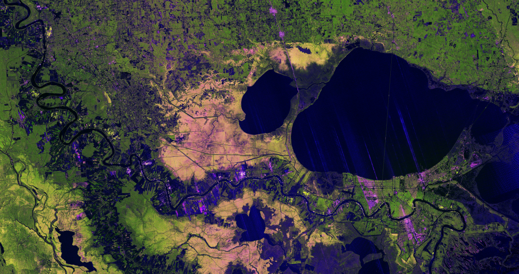
A new image from the NISAR mission shows off the satellite’s ability to reveal details of Earth’s surfaces. The science team also released new sample data. A U.S.-Indian Earth satellite’s ability to see through clouds, revealing insights and characteristics of our planet’s surface, is on display in a colorful, newly released image showing the Mississippi River Delta region in southeastern Louisiana. Created with data collected by the NISAR (NASA-ISRO […]

A total lunar eclipse will redden the Moon on March 3, 2026. Here’s what you need to know.
A mild La Niña caused greater rainfall over the Amazon basin, which offset rising sea levels due to record warming of Earth’s oceans. The rise in the global mean sea level slowed in 2025 relative to the year before, an effect largely due to the La Niña conditions that persisted over most of the year. […]
Along with this stunning image is the first-ever global estimate of river water discharge and overall sediment suspension.
…
To understand what Americans are experiencing with this winter blast, we need to look more than 20 miles above the surface of Earth, to the stratospheric polar vortex.
…
A 250th anniversary only comes once in a lifetime.

Space-based technology could help track plastic and other flotsam by its ‘fingerprints.’ In late 2025, scientists reported that, for the first time, they were able to detect concentrations of plastic pollution on land using NASA’s Earth Surface Mineral Dust Source Investigation (EMIT) sensor aboard the International Space Station. The technology has inspired marine researchers to […]
Antarctica’s subglacial bedrock was previously one of the least-mapped planetary surfaces in our solar system.

NASA satellites are helping Maine oyster farmers pick better sites and plan when oysters will be ready to harvest.
The image shows just how large and devastating these events can be.